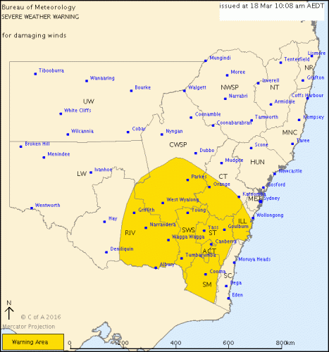
THE Bureau has issued a warning for our region.
If you get a photo of the wild weather feel free to email it to john@citynews.com.au for publication.
A cold front moving across New South Wales during Friday is bringing vigorous west to northwesterly winds to many southern areas ahead of the front, with a very gusty west to southwesterly change moving through along the front.
DAMAGING WINDS, averaging 60 to 70 km/h with peak gusts in excess of 90 km/h are expected about the Illawarra, Southern Tablelands, South West Slopes, Snowy Mountains, ACT and parts of the Central Tablelands, Riverina and Central West Slopes and Plains both ahead of and as the cold front moves through. Areas above 1900 metres may experience winds averaging 80 to 90 km/h with peak gusts in excess of 110 km/h.
Locations which may be affected include Nowra, Orange, Canberra, Goulburn, Wagga Wagga and Albury.
Griffith AWS recorded an average speed of 61 km/h with a gust of 102 km/h at 10am.
The State Emergency Service advises that people should:
* Move vehicles under cover or away from trees.
* Secure or put away loose items around your house, yard and balcony.
* Keep clear of fallen power lines.
* For emergency help in floods and storms, ring your local SES Unit on 132 500.The next warning is due to be issued by 5:10 pm.
Who can be trusted?
In a world of spin and confusion, there’s never been a more important time to support independent journalism in Canberra.
If you trust our work online and want to enforce the power of independent voices, I invite you to make a small contribution.
Every dollar of support is invested back into our journalism to help keep citynews.com.au strong and free.
Thank you,
Ian Meikle, editor


Leave a Reply