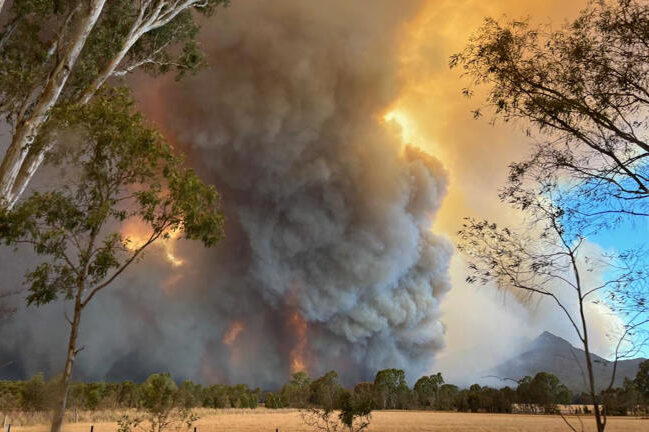
THE Orroral Valley Fire has ballooned to 14,904 hectares of scorched land in the Namadgi National Park as it ends today (January 29) on a lower “advice” level. A break from the frightening “emergency” conditions of yesterday.
The map is a sobering reminder of the ugly black scab the fire has created and its relationship to Canberra’s south. It remains out of control and the ESA is bracing against extreme and difficult weather conditions as things dangerously heat up towards the weekend with the Weather Bureau forecasting 39C tomorrow, then 42C on Friday and Saturday before a 60 per cent chance of showers and the chance of a thunderstorm, with a top of 35C on Sunday.
Who can be trusted?
In a world of spin and confusion, there’s never been a more important time to support independent journalism in Canberra.
If you trust our work online and want to enforce the power of independent voices, I invite you to make a small contribution.
Every dollar of support is invested back into our journalism to help keep citynews.com.au strong and free.
Thank you,
Ian Meikle, editor


![Canberra’s woodchopping association – the Hall and District Axemen’s Club – is rebranding to Capital Country Woodchopping.
“We didn’t want to be exclusively a Canberra association and we deliberately left any gender-specific wording out in the new name,” says president Cheyanne Girvan, 32.
“We also went a different [way] to other associations under NSW by not including ‘association’ in our name.”
Four years ago the Hall and District Axemen’s club’s membership was 25.
Cheyanne says this name change will give the club the versatility to grow into other areas and on to greater things.
To read on about Cheyanne's story with the woodchoppers, visit our website at citynews.com.au or click the link in our bio!
@@capitalcountrywoodchopping
#woodchopping #woodchoppinggirl #woodchoppingaustralia #axemen #axewomen #woodcutter #canberrastories #storiesthatmatter #citynews #journalism](https://citynews.com.au/wp-content/plugins/instagram-feed/img/placeholder.png)
Leave a Reply