By Laine Clark in Brisbane
Roads have been cut and communities isolated but flooding has been welcomed by one inundated region.
As Western Australia mops up after a cyclone direct hit, Queensland is still being impacted by record rainfall.
The state’s northwest is the latest region to endure flooding after weeks of wet weather finally reached its catchments.
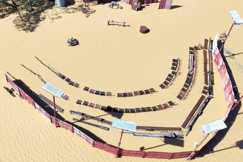
Longreach has been one of the worst hit, with pictures of inundated tourist attraction Outback Pioneers showing the extent of flooding that has stretched for 10 days.
But local mayor Tony Rayner said it has largely been welcomed in the region after a dry 2024.
“A moderate flood is always a welcome flood,” he told AAP.
“We are waiting for the wet season to come … to allow our properties to have enough feed and water to get through the year.”
A string of warnings remain across the north after heavy rain triggered flooding that claimed two lives and forced hundreds of residents to evacuate.
“The flooding situation in Queensland is ongoing,” the Bureau of Meteorology’s Miriam Bradbury told AAP.
“Some areas are still seeing significant flooding but in general most of that is on a decreasing trend.”
February 2025 is officially the wettest month in history for some north Queensland towns with Paluma near Townsville receiving two metres of rainfall, double what Sydney receives in a year.
A relief package for impacted home owners is being finalised but the Queensland government said it was too early to estimate the damage bill.
Main arterial the Bruce Highway has finally reopened north to Cairns after supplies had to be flown to isolated regions.
In WA, floodwaters triggered by Cyclone Zelia’s recent coastal crossing near Port Hedland appear to have peaked in the region.
Remnants of the system remain but inland WA was expected to dry out in the next 24 hours, the bureau said.
However major flooding at the Pilbara’s De Grey River catchment is set to be ongoing “for some time”.
Freight routes across the remote Pilbara region are set to be cut for days, sparking panic buying with supermarket shelves stripped bare at Broome.
However, contingencies were in place to have trucks arrive via South Australia and the Northern Territory to help restock stores.
Floodwaters are expected to ease just as two cyclones look set to develop off Australia’s coast.
A tropical low is set to form in the Coral Sea off Queensland, with a “low” chance of developing into a cyclone from Friday.
Another may form off WA’s northwest coast with a “moderate” chance of becoming a cyclone from Friday.
However, neither are expected to impact Australia.
After Zelia’s arrival, the cyclone name list will head back to the top of the alphabet when the next system forms.
However don’t expect Cyclone Anthony to impact Australia any time soon.
The name has been skipped on the list due to its clash with Prime Minister Anthony Albanese, with the next cyclone to be called Alfred.
“Given the current prominent person in Australian politics we have moved onto the next name on the list,” Ms Bradbury said.
“This is not the first time this has happened. We do also retire names if we have particularly impactful systems – for example there will never be another Cyclone Tracy.
“So we are skipping Anthony and moving next to Alfred.”
Who can be trusted?
In a world of spin and confusion, there’s never been a more important time to support independent journalism in Canberra.
If you trust our work online and want to enforce the power of independent voices, I invite you to make a small contribution.
Every dollar of support is invested back into our journalism to help keep citynews.com.au strong and free.
Thank you,
Ian Meikle, editor


Leave a Reply